| The
Philadelphia End of the Bethlehem Branch
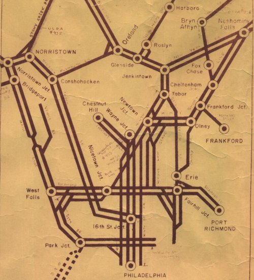
In
the map above, dated 01 March 1974, the Bethlehem Branch can be followed
along the southern end of it's route. The Bethelem Branch is the line which
starts at Oreland (connection with the Plymouth Branch) at the top of the
map, continues south through Glenside (connection with the New Hope Branch)
and Jenkintown (connection with the New York Branch) and then diverges
from the Ninth Street Branch at Tabor Junction. Bethlehem Branch continues
south, passing under the New York Short Line in Olney and connecting with
the Olney Branch at Erie (site of the old Erie Avenue Yard). The line passed
over the Richmond Branch at Fairhill Junction and finally dwindled to single
track as it approached the old North Penn terminal at Third and Berks Streets.
The line did ramble south a bit further to a connection with the Willow
and Noble Street Branch, but the connection is not shown on the map. |
 |
|
|
|
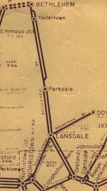
| The
Northern End of the Bethlehem Branch
In
the map below, the rest of the Bethlehem Branch may be seen. This time,
Jenkintown and Oreland are on the bottom of the map. The line leaving Third
and Berks in the city was an uphill battle. Once the line exited the city
limits and passed through suburbia and entered the rolling farm lands north
of Jenkintown that the apparent lack of following a river valley course
became apparent. The line north of Jenkintown has been likened to a roller
coaster, with grades as steep as 1.2 per cent. The single track segment
around Perkasie was the only remaining tunnel on the line. Another tunnel
existed at Gwynedd Valley, but it was made in to a deep cut when that portion
of the line was electrified in the 1930's. The Perkasie tunnel was originally
constructed with double track, but as equipment grew the track was first
made a gauntlet and finally single tracked through the opening.
|
|
|
|